A project of the Center for Complex Engineering Systems (CCES)
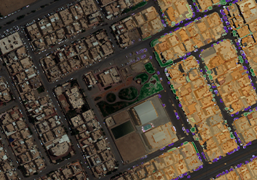
Satellite imagery provides an incredibly rich source of data, but it is often challenging to utilize. In this project, we are developing advanced methods in image processing to accurately extract information from images, periodically and in a fully automated fashion. Our methods leverage a variety of techniques from deep learning such as Convolutional Neural Networks and Generative Adversarial Networks to locate, augment, or identify various objects within an urban setting, including buildings, cars, vegetation, etc. Our end goal is to advance, merge, and customize these methods for various applications, such as the analysis of urban dynamics, assessment of disaster damage, (e.g. flooding), or even the detection of overcrowded parking areas.
A project of the Center for Complex Engineering Systems (CCES)